


7 km | 7.8 km-effort
![Trail On foot Chlum u Třeboně - [Z] Majdalena žst. - Starý Kanclíř - Photo](https://media.geolcdn.com/t/1900/400/160cb673-a34f-4369-9d35-56dda7405eee.jpeg&format=pjpeg&maxdim=2)

Tous les sentiers balisés d’Europe GUIDE+


FREE GPS app for hiking
 SityTrail
IGN / Geographical institutes
SityTrail World
The world is yours!
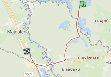
Trail On foot of 4 km to be discovered at Southwest, Jihočeský kraj, Chlum u Třeboně. This trail is proposed by SityTrail - itinéraires balisés pédestres.
Trail created by cz:KČT.
![Trail On foot Chlum u Třeboně - [Z] Majdalena žst. - Starý Kanclíř - Photo 1](https://media.geolcdn.com/t/2048/auto/c4b6e83d-3527-43e0-98bc-2ee4b427dac9.jpeg&format=jpg&maxdim=0 "Trail On foot Chlum u Třeboně - [Z] Majdalena žst. - Starý Kanclíř - Photo 1")
![Trail On foot Chlum u Třeboně - [Z] Majdalena žst. - Starý Kanclíř - Photo 2](https://media.geolcdn.com/t/2048/auto/356781d4-b52e-4d7d-b1be-cbe678a854a5.jpeg&format=jpg&maxdim=0 "Trail On foot Chlum u Třeboně - [Z] Majdalena žst. - Starý Kanclíř - Photo 2")
![Trail On foot Chlum u Třeboně - [Z] Majdalena žst. - Starý Kanclíř - Photo 3](https://media.geolcdn.com/t/2048/auto/c2f221a6-c689-4b9a-b882-aaf971978c97.jpeg&format=jpg&maxdim=0 "Trail On foot Chlum u Třeboně - [Z] Majdalena žst. - Starý Kanclíř - Photo 3")
![Trail On foot Chlum u Třeboně - [Z] Majdalena žst. - Starý Kanclíř - Photo 4](https://media.geolcdn.com/t/2048/auto/6a663ea8-781a-407a-8c59-6b4496dc1111.jpeg&format=jpg&maxdim=0 "Trail On foot Chlum u Třeboně - [Z] Majdalena žst. - Starý Kanclíř - Photo 4")
![Trail On foot Chlum u Třeboně - [Z] Majdalena žst. - Starý Kanclíř - Photo 5](https://media.geolcdn.com/t/2048/auto/4664fcbd-601b-42da-affc-8fd3fb13b226.jpeg&format=jpg&maxdim=0 "Trail On foot Chlum u Třeboně - [Z] Majdalena žst. - Starý Kanclíř - Photo 5")
![Trail On foot Chlum u Třeboně - [Z] Majdalena žst. - Starý Kanclíř - Photo 6](https://media.geolcdn.com/t/2048/auto/e53bfee8-0c92-41ae-bf59-42326f09ef31.jpeg&format=jpg&maxdim=0 "Trail On foot Chlum u Třeboně - [Z] Majdalena žst. - Starý Kanclíř - Photo 6")
![Trail On foot Chlum u Třeboně - [Z] Majdalena žst. - Starý Kanclíř - Photo 7](https://media.geolcdn.com/t/2048/auto/0b1cd775-2100-43e1-a74b-85076c945996.jpeg&format=jpg&maxdim=0 "Trail On foot Chlum u Třeboně - [Z] Majdalena žst. - Starý Kanclíř - Photo 7")
![Trail On foot Chlum u Třeboně - [Z] Majdalena žst. - Starý Kanclíř - Photo 8](https://media.geolcdn.com/t/2048/auto/24176e0e-37e8-43d5-9634-0bb61045f9ef.jpeg&format=jpg&maxdim=0 "Trail On foot Chlum u Třeboně - [Z] Majdalena žst. - Starý Kanclíř - Photo 8")
![Trail On foot Chlum u Třeboně - [Z] Majdalena žst. - Starý Kanclíř - Photo 9](https://media.geolcdn.com/t/2048/auto/68d08838-6d66-4184-9555-c6d3f1f49a51.jpeg&format=jpg&maxdim=0 "Trail On foot Chlum u Třeboně - [Z] Majdalena žst. - Starý Kanclíř - Photo 9")
![Trail On foot Chlum u Třeboně - [Z] Majdalena žst. - Starý Kanclíř - Photo 10](https://media.geolcdn.com/t/2048/auto/160cb673-a34f-4369-9d35-56dda7405eee.jpeg&format=jpg&maxdim=0 "Trail On foot Chlum u Třeboně - [Z] Majdalena žst. - Starý Kanclíř - Photo 10")
![Trail On foot Chlum u Třeboně - [M] Chlum u Třeboně - Majdalena - Photo](https://media.geolcdn.com/t/375/260/c5b3127b-51b9-444c-873e-2820e6bdc5ba.jpeg&format=jpg&maxdim=2)
On foot
![Trail On foot Třeboň - [Z] U Dlouhého mostu - Obora - Photo](https://media.geolcdn.com/t/375/260/ext.jpg?maxdim=2&url=https%3A%2F%2Fstatic1.geolcdn.com%2Fsiteimages%2Fupload%2Ffiles%2F1545311037marcheuse_200dpi.jpg)
On foot